The
Ethiopian rift valley: geography and morphology
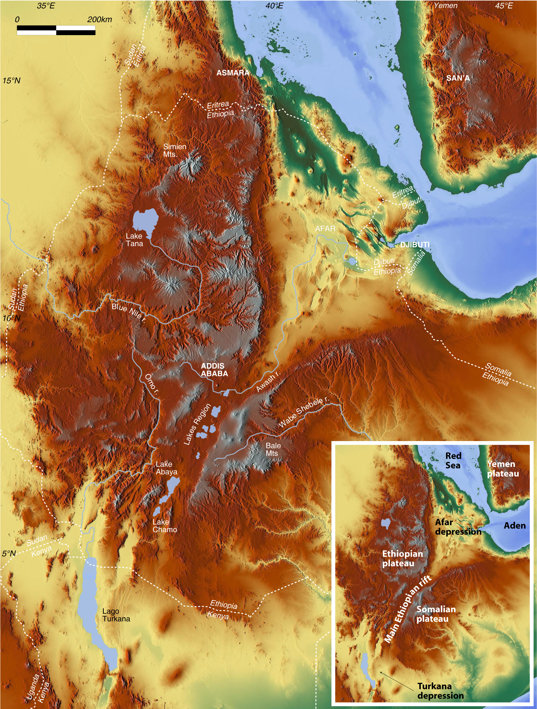
The Ethiopian sector of the East African Rift system extends for more than 1000 km in a NE-SW to N-S direction
from the Afar depression, at Red Sea-Gulf of Aden junction,
southwards to the Turkana depression. The southern boundary
may be traced at latitude ~5°N, south of the area where
the rift is divided into two branches (Chamo basin to the west
and Galana basin to the east) by the Amaro Mts; southwards,
the rift zone widens and deformation becomes more complex being
accommodated by the ~300 km-wide system of basins and ranges
(referred to as Broadly Rifted Zone) that characterizes the
overlapping area between the Ethiopian and Kenya Rifts. To the
north, the rift corresponds to the Afar depression, a wide triangular
zone of tectonic collapse in which the rift valley joins the
Red Sea and Gulf of Aden oceanic basins.

Morphology of the
Ethiopian sector of the rift valley (click for a larger
version)
The typical rift morphology is most typically
developed in the Main Ethiopian Rift, a 500km-long sector that
from the Afar depression (latitude 9°40'N) reaches the region
of lakes Abaya and Chamo (latitude 5°30'N). In this rift
sector, a ~80km-wide rift valley (Ethiopian Rift valley sensu
stricto of Mohr, 1983) separates the uplifted western (Ethiopian)
and eastern (Somalian) plateaus. Large tectonic scarps connect
the valley floor with the surroundings plateaus; the plateaus
rise to elevations >2000 m above sea level; north of latitude
9° the highest elevations are attained by the Ethiopian
Plateau, whereas south of this latitude the Somalian plateau
reaches the highest elevations. The rift floor raises in elevation
from the Turkana depression up to the main watershed between
the Meki and Awash rivers immediately north of Lake Ziway, where
the rift valley attains its maximum elevation at ~1700 m asl.
Northwards the rift floor descends regularly into the Afar depression
where, over extensive areas, it lies below sea level. Local
increases in the elevation of the rift valley are generally
due to volcanic edifices, as in the northern MER where several
volcanoes raise from the flat rift floor.
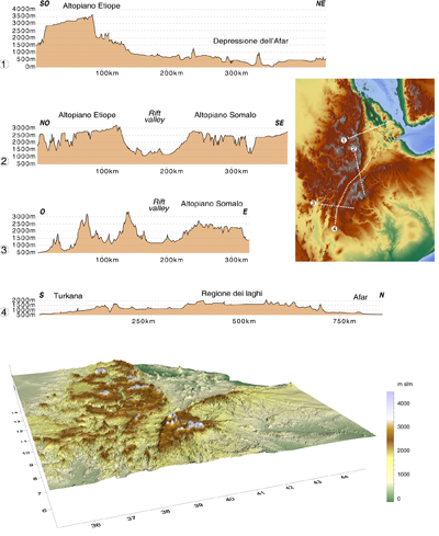
Topographic
profiles and 3D digital elevation model of the Ethiopian sector
of the rift valley (click for a larger version)
Quite different is the morphology of the Afar depression, a triangular-shaped lowland where elevation drops uniformly from ~1000 m in the southwest to below sea level in the north (Danakil depression) and in the east, where the shores of Lake Asal, fluctuating at around 155 m below sea level, represent the lowest subaerial point of the African continent. The depression, which hosts one of the most hostile environments on Earth (maximum temperatures can exceed 50°C during the summer wet season; Dallol, at the northern tip of Afar, has the highest average annual temperature for an inhabited location: 34°C between 1960 and 1966) is separated from the Ethiopian and Somalian plateaus by major fault escarpments. Separation from the Red Sea and Gulf of Aden is defined less dramatically by the low relief of the Danakil block (also called Danakil Alps) and the even more subdued hills of the Ali-Sabieh block. To the north, Afar narrows in the Danakil depression between the Danakil block and the Ethiopian escarpment, which connects the Afar lowland to the Gulf of Zula. The Gulf of Tadjoura separates the Ali-Sabieh and Danakil blocks, connecting Afar to the Gulf of Aden. As is the case everywhere in Afar, young volcanic centres prevent marine waters from flooding the region.